West Elsdon: From Marshy Swampland to Southwest Side Cornerstone
Mar 03, 2026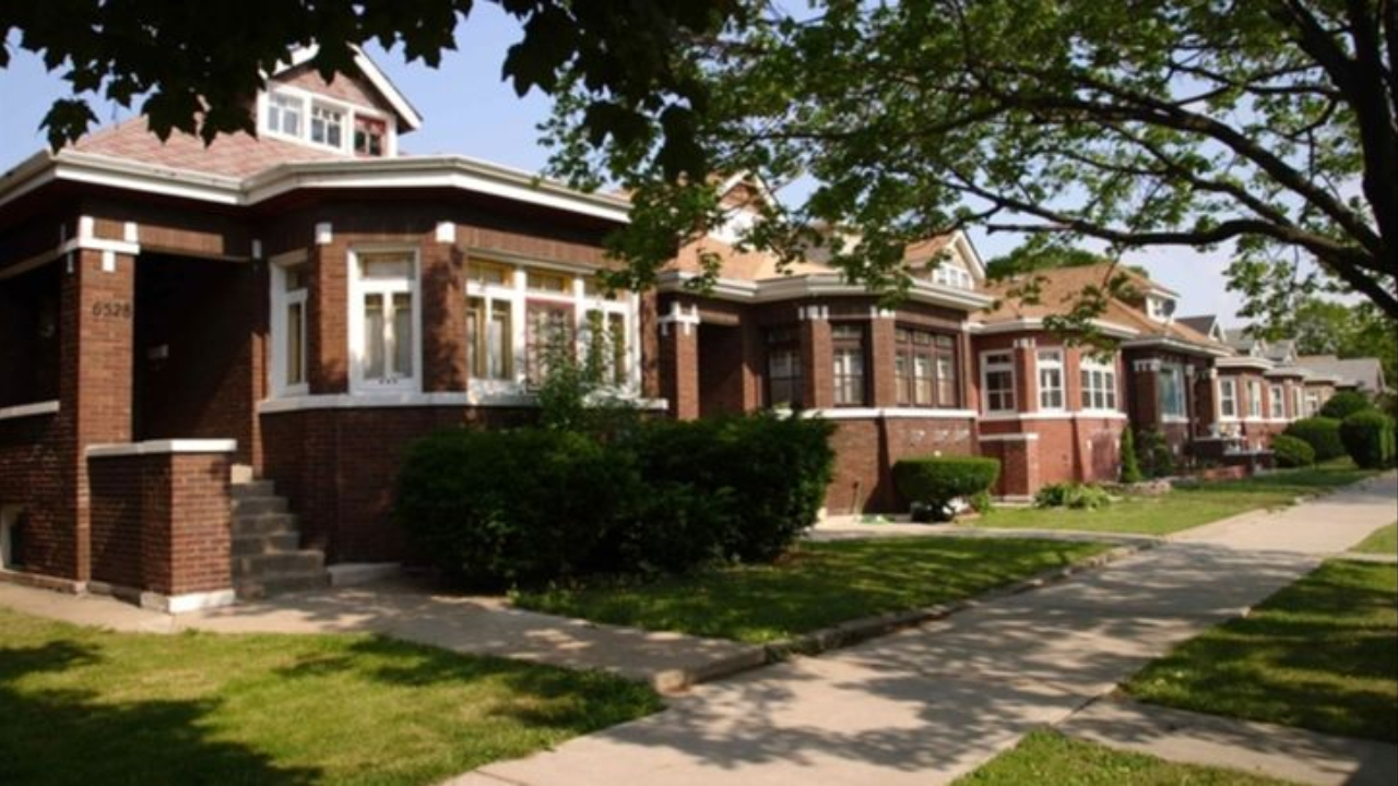
West Elsdon sits on Chicago's Southwest Side, approximately nine miles from the Loop. It is bounded by the Belt Railway to the north (roughly 51st Street), 59th Street to the south, the Grand Trunk Western Railroad tracks to the east (near Pulaski Road), and Cicero Avenue to the west directly adjacent to Midway Airport. At just one square mile, it is one of Chicago's most compact community areas, yet it carries a history that punches well above its size.
Trivia Question
West Elsdon's neighborhood streets are nicknamed "K-Town" because all of its north-south streets begin with the letter K. But why does the letter K correspond to this particular location in Chicago's grid system?
West Elsdon by the Numbers
A Marshy Beginning
Before the early twentieth century, the land that would become West Elsdon was a marshy remnant of an ancient glacial lake. The terrain was largely unsuitable for farming or dense settlement, leaving the area sparsely populated compared to neighborhoods closer to the city center.
The neighborhood's name traces back to the railroad workers who settled here in the late 1800s. The Grand Trunk Railroad was built through the area in 1880, and the small community of laborers who worked those tracks came to be called "Elsdon." That name attached to the western portion of the corridor stuck when the broader community area was later formalized.
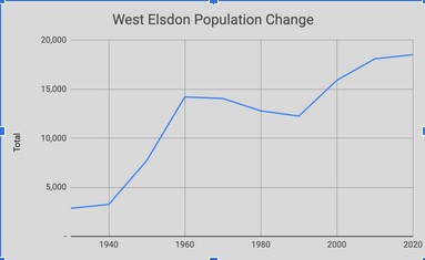
When Chicago annexed the Town of Lake in 1889, West Elsdon came under city jurisdiction. Municipal services followed, but progress was slow given the swampy terrain. The neighborhood remained largely rural well into the early twentieth century.
Midway Airport and the Path to Development
Two forces drove West Elsdon's eventual growth: the expansion of nearby industrial employment and the rise of Midway Airport. Originally known as Chicago Municipal Airport, Midway opened in the 1920s just west of the neighborhood's boundary. Its presence brought jobs, economic activity, and a steady stream of workers looking for housing nearby.
During the 1930s, Polish-Americans and other Central European immigrants began settling the area in larger numbers as streets were paved, sewers were installed, and schools were built. Progress stalled during the Great Depression; it was reportedly still common to see cows grazing along 55th Street as late as 1938 but the postwar era brought a dramatic acceleration.
After World War II, brick bungalows and ranch-style homes filled in the remaining open land at a rapid clip. West Elsdon transformed from a semi-rural outpost into a recognizable urban neighborhood within the span of a decade.
K-Town and its Eclectic Housing Stock
West Elsdon is part of Chicago's famous bungalow belt, but its housing stock is notably more varied than many neighboring communities. Brick bungalows dominate the residential streets, but Cape Cods, Tudor-style homes with steeply pitched roofs, Prairie-influenced structures, and even converted corner stores-turned-residences give the neighborhood an eclectic architectural character.
The nickname "K-Town" reflects an unusual quirk of Chicago's street-naming system. All north-south streets in West Elsdon begin with the letter K — Karlov, Keeler, Kilbourn, Kildare, Kostner, and others.
The Airport Homes Race Riots of 1946
The most historically significant and troubling chapter in West Elsdon's past unfolded in December 1946. As part of its effort to address a severe postwar housing shortage, the Chicago Housing Authority (CHA) established a temporary veterans' housing project near Midway Airport called "Airport Homes," located at 60th Street and Karlov Avenue — on the West Lawn side of the boundary, but just steps from West Elsdon.
When the CHA attempted to move two Black veteran families into the project alongside white veterans, residents of West Elsdon and neighboring West Lawn responded with mass violence. A mob of thousands formed around the housing project, and the chaos that followed was described as the worst racially inspired violence the city had seen in thirty years. The Black families were ultimately forced out.
Chicago's major newspapers largely suppressed coverage of the riots at the request of the city's Commission on Human Relations, which feared publicity would intensify the violence. As a result, the Airport Homes riots remain one of the lesser-known episodes in Chicago's long history of housing segregation — despite their scale and significance.
The West Elsdon Civic Association, formed in part around opposition to integrated public housing, became one of the loudest opponents of the CHA's efforts. The association remained an active participant in the citywide "No-CHA" coalition opposing scattered-site public housing well into the 1970s.
Demographic Transformation
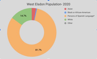
For most of the postwar decades, West Elsdon was overwhelmingly white and ethnically Central European, dominated by Polish-American families who anchored their community around local Catholic parishes, schools, and neighborhood businesses. The 1960 census recorded only five people of color living in the entire community.
Beginning in the late 1980s and accelerating through the 1990s, Mexican-American families began settling in West Elsdon, primarily in the eastern sections near Pulaski. Many longtime white residents departed over time, though historians note this transition was driven more by aging residents leaving city life than by classic white flight dynamics.
By the 2020 census, Hispanic residents — predominantly of Mexican origin — made up approximately 85 percent of West Elsdon's population. The neighborhood today retains the working-class, homeowner-focused identity it has held for generations. What has changed is who those homeowners are.
West Elsdon Today
West Elsdon remains one of Chicago's quieter, more residential communities — easy to overlook from the outside but vibrant within. Its proximity to Midway Airport makes it a practical choice for airline workers and frequent travelers, and the Pulaski CTA Orange Line stop connects residents directly to the Loop.
The neighborhood's culinary scene has become a quiet point of pride, anchored by Mexican restaurants, taquerias, and bakeries. Some local restaurants have grown popular enough to open satellite locations downtown. Parks like Senka Park, Stohacker Park, and Pasteur Park serve as neighborhood gathering spaces, while the much larger Marquette Park lies just to the southeast.
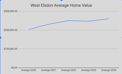
The median home sale price has climbed in recent years, reflecting both the city-wide rise in property values and continued demand from working-class families seeking stable, affordable homeownership — the same aspiration that drew Polish immigrants to these streets in the 1940s, and the same one that draws Mexican-American families today.
West Elsdon's story is one of repeated reinvention: from swamp to railroad hamlet to bungalow suburb to a flashpoint in Chicago's housing wars to a majority-Latino community. Its small size belies the weight of its history.
Trivia Answer
The K streets fall roughly eleven miles west of Indiana's border with Illinois and K is the eleventh letter of the alphabet. Chicago's planners intended to name north-south streets alphabetically from east to west, starting at the state line. The plan was never fully implemented across the city, but in West Elsdon and a handful of surrounding neighborhoods, it took hold, giving the area its enduring nickname: K-Town.
Stay connected with news and updates!
Join our mailing list to receive the latest news and updates from our team.
Don't worry, your information will not be shared.
We hate SPAM. We will never sell your information, for any reason.
