Washington Heights: Rails, Ridges, and the Long Work of Belonging
May 05, 2026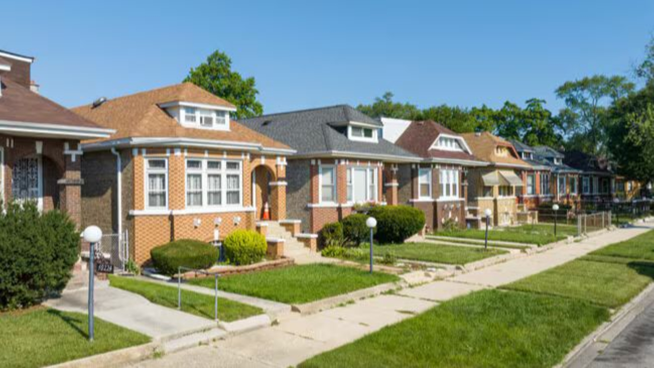
Washington Heights sits on Chicago's far South Side, about twelve miles from the Loop. It is bounded by 89th Street to the north, 107th Street to the south, and two railroad lines that define its eastern and western edges, the Norfolk Southern tracks near Ashland Boulevard to the west, and another rail corridor near Stewart Avenue to the east. Within those boundaries are three distinct settlements that grew up separately and were eventually stitched together by annexation: Washington Heights proper, Brainerd to the northwest, and Fernwood to the southeast. Together they form a community area that has been shaped, divided, and reinvented by the same force that created it in the first place: the railroad.
Trivia Question
What is the name of the library in the Washington Heights area that houses the largest collection of African American History outside of the National Museum of African American History and Culture (NMAAHC)?
Washington Heights by the Numbers
Rails, Ridges, and the First Settlers
The land that became Washington Heights sits along the Blue Island Ridge, an area that runs through Beverly, Morgan Park, and Mount Greenwood and gave early settlers a narrow band of elevated, well-drained ground above the surrounding flatlands. German and Irish farmers arrived in the 1830s and 1840s, working the ridge and the prairie beside it, but the community remained sparse and rural for decades. It was the railroads, not the soil, that finally brought people in numbers.
By the mid-1860s, rail lines were threading through the South Side, and land speculators followed close behind. In 1866, a developer named Willis M. Hitt platted a subdivision along the tracks and opened a post office named Washington Heights borrowing the name from the elevated terrain of the adjacent Beverly ridge. The settlement grew steadily through the 1870s, and by 1874 it had enough residents to formally incorporate as a village. Brainerd followed to the northwest in 1880, and Fernwood was platted to the southeast in 1883, both of them growing in the orbit of the same rail corridors.
Chicago annexed Washington Heights and Brainerd in 1890, and Fernwood followed in 1891, drawn into the city by the promise of improved streets, water service, and schools. Those promises arrived slowly. Roads north of the Rock Island Railroad tracks remained unpaved until 1925. The roads south of the tracks waited until 1927. Gas lines came in 1905, telephones in 1907. The neighborhood's development was real, but it moved at the pace of the far edge of a growing city — behind the center, always catching up.
The Bungalow Years
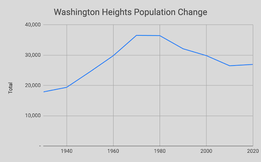
Washington Heights built its character in the first half of the twentieth century, as brick bungalows went up block by block across the community area and a working-class Irish, German, and Swedish population established the institutions that organized daily life. By 1930, the population had reached roughly 18,000 and was still growing. Catholic parishes, civic organizations, and the Metra Rock Island Line (which ran commuters directly to downtown) gave the neighborhood the stability of a self-contained community that happened to be within Chicago's city limits.
The Brainerd neighborhood, in the northwestern section of the community area, developed a particularly cohesive identity of its own. Its bungalows were well-built and well-maintained, and its residents took pride in the physical character of the streets. That pride left a legacy: the Brainerd Historic Bungalow District was eventually recognized on the National Register of Historic Places, and its most famous native son Richard Driehaus, the financier and philanthropist who grew up on those streets before building a fortune in Chicago — became one of the most passionate champions of bungalow preservation in the country. He funded restoration efforts and advocacy work that elevated the architectural significance of the Chicago bungalow long after he had moved on.
A Neighborhood Divided….. Literally
The most physically dramatic event in Washington Heights' modern history arrived not as a social crisis but as a construction project. In the late 1960s, the Dan Ryan Expressway's West Leg Interstate 57 was cut directly through the western portion of the community area. The expressway did not simply add traffic; it displaced homes, severed streets, and drew a hard physical line through a neighborhood that had been continuous for nearly a century.
The Dan Ryan came at precisely the moment Washington Heights was undergoing its demographic shift. As African-American families began moving southward from the expanding Black Belt in the 1950s and 1960s, blockbusting real estate agents worked the neighborhood the same way they had worked Auburn Gresham, Roseland, and dozens of other South Side communities stoking fear, churning sales, and pocketing the difference between what panicked white sellers accepted and what incoming Black buyers were charged. The neighborhood that had been nearly entirely white in 1950 was 75 percent Black by 1970, and 98 percent Black by 1980.
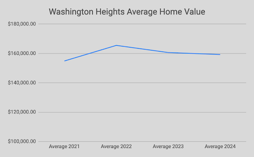
What distinguished Washington Heights from some of its neighbors was what held through that transition. The homeownership ethic that the Irish and German families had embedded in the community's housing stock did not dissolve when the population changed. Black middle-class families, many of them city workers, teachers, and small business owners moved in and maintained the bungalows, paid their mortgages, and kept the blocks stable. Washington Heights declined somewhat in the decades that followed, but it never became the kind of distressed neighborhood that disinvestment had made of communities just a few miles away. That distinction mattered, and still does.
The Major Taylor Trail and the Neighborhood Today
Running along an old railroad right-of-way through Washington Heights is the Major Taylor Trail, a six-mile paved bicycle and pedestrian path named for Marshall "Major" Taylor, an African-American cyclist who was one of the most celebrated racing champions of the late nineteenth century and one of the first Black athletes to achieve international fame. The trail connects the Dan Ryan Woods in Chicago with Whistler Woods in Riverdale, threading through Brainerd, Beverly, Morgan Park, and Roseland along the way. It is a quiet amenity that most people outside the South Side don't know exists, and a fitting memorial for an athlete whose achievements were similarly overlooked for most of the twentieth century.
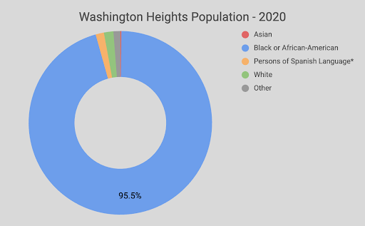
Washington Heights today is a predominantly Black middle-class community that has held its character through cycles of disinvestment that felled neighborhoods around it. Its homeownership rate remains high, its bungalows are largely well-maintained, and its civic institutions — the library above all — continue to serve the community with genuine distinction. The population has declined modestly since 2000, tracking the broader pattern of Black middle-class departure from Chicago that has emptied parts of the South and West Sides over the past two decades. That pressure is real and ongoing.
What Washington Heights has going for it is what it has always had: a ridge of solid ground, a set of transit connections to the rest of the city, and a population that has repeatedly chosen to invest in the blocks it lives on rather than walk away. The railroad created this neighborhood. The expressway divided it. Neither determined what it became. That was left to the people who stayed.
Trivia Answer
Woodson Regional Library and the Vivian Harsh Collection
The most significant cultural institution in Washington Heights opened on December 19, 1975: the Carter G. Woodson Regional Library, the Chicago Public Library's South District regional branch, located at 9525 South Halsted Street. The library was named for the historian known as the "father of Black history," whose connection to Chicago was the direct origin story of the annual February observance that celebrates African-American history and culture nationwide.
The library's greatest asset is the Vivian G. Harsh Research Collection of Afro-American History and Literature — the largest collection of African-American photographs, manuscripts, and biographical records in the Midwest. The collection was assembled over decades by Vivian G. Harsh, the first African-American branch head in Chicago Public Library history, who began acquiring materials on Black history at the George Cleveland Hall Branch in Bronzeville in the 1930s and built it into a research archive of national significance. When the Woodson Regional Library opened, the Harsh Collection moved with it to Washington Heights, giving the South Side a permanent home for primary source material that scholars, students, and community researchers have used ever since.
The library was expanded in 1998 to include a reading room and exhibit gallery, and underwent a major renovation in 2018 that added study rooms, a children's space, and a digital media center for teens. It remains one of the most visited and respected public library branches in Chicago — an institution that carries more historical weight per square foot than almost anywhere else on the South Side.
Stay connected with news and updates!
Join our mailing list to receive the latest news and updates from our team.
Don't worry, your information will not be shared.
We hate SPAM. We will never sell your information, for any reason.
