Garfield Ridge: From Ancient Portage Route to Chicago's Southwest Frontier
Mar 18, 2026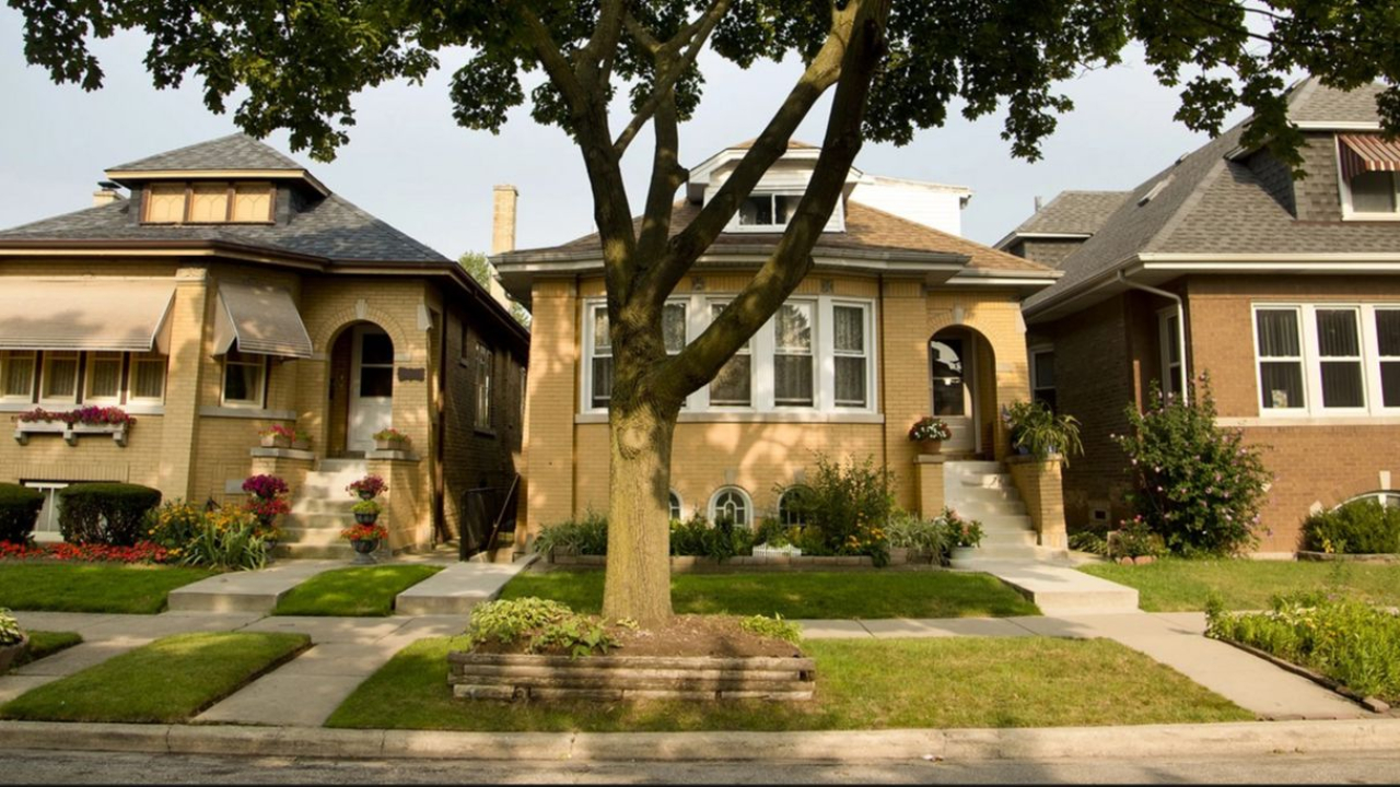
Garfield Ridge occupies Chicago's far Southwest Side, roughly ten miles from the Loop. It is bounded by the Stevenson Expressway (Interstate 55) to the north, 59th Street to the south, Harlem Avenue to the west, and railroad tracks just east of Cicero Avenue to the east. The northern half of Midway International Airport sits within or directly adjacent to its southern edge, and Archer Avenue, one of the oldest roads in Illinois cuts diagonally through the neighborhood's heart. At just over four square miles, Garfield Ridge is one of the larger community areas on the Southwest Side, and one of the most quietly layered in history.
Trivia Question
Long before Chicago existed, a small body of water in what is now Garfield Ridge served as a crucial link in a water route used by Native Americans and later by French explorers, one that ultimately shaped the location and growth of the entire city. What was this body of water called, and why did it matter so much?
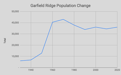
Garfield Ridge By the Numbers
Land Speculators, Dutch Farmers, and Sleepy Hollow
For most of the nineteenth century, the land that would become Garfield Ridge served primarily as a passageway rather than a place to live. Archer Avenue, which follows the path of an ancient Native American trail and later the Illinois and Michigan Canal, was a transit corridor for goods moving between Chicago and the Illinois River valley. Settlement was sparse.
The area's most prominent early landholder was the same "Long John" Wentworth who left his mark on neighboring Clearing and Garfield Ridge alike. The former mayor and U.S. Senator purchased much of the land through the 1850s and 1860s, eventually accumulating roughly 4,700 acres across what are now multiple Southwest Side neighborhoods. He built his country estate at what is today 55th and Harlem and bred fine cattle and horses on his holdings until his death in 1888.
After Wentworth's death, his land passed to family and was leased to Dutch truck farmers who clustered around Archer Avenue and Austin Avenue in the late 1800s. They founded two Reformed churches in the area and formed the core of Garfield Ridge's earliest stable community. Meanwhile, in the far northeastern corner of the neighborhood — east of Cicero Avenue, north of 47th Street — a small residential enclave called Sleepy Hollow began to take shape around 1907, becoming one of the first genuine neighborhoods within what would eventually become Garfield Ridge.
Chicago annexed the area in phases, completing the process by 1921. It was around this time that the name "Garfield Ridge" came into common use, derived from Garfield Boulevard (55th Street, named for President James Garfield) and the glacial ridge that bisects the community. The neighborhood had previously gone by the more prosaic name "Archer Limits" — a reference to the fact that Archer Avenue and Cicero Avenue had marked the western and southern edges of the city.
The Airport and the Bungalow Boom
Garfield Ridge's transformation from a rural backwater into a functioning urban neighborhood was driven almost entirely by two forces: the opening of Chicago Municipal Airport in 1926 later renamed Midway and the wave of Eastern European immigration, particularly from Poland, that followed.
By 1930, nearly 30 percent of Garfield Ridge's residents were foreign-born, and more than half had at least one foreign-born parent. Polish immigrants dominated, settling around Archer Avenue and establishing St. Camillus parish, which began as a mission church and grew into a neighborhood anchor. Czech, Lithuanian, and other Central European families filled in the surrounding blocks.
Developer Frederick Bartlett had begun laying out residential subdivisions as early as 1912, marketing them as "Bartlett Highlands" (gated communities), at least in aspiration, with a sales office at Archer and 62nd Court. Two stone gate posts from that era still stand today at Archer and Nordica, and Archer and Melvina. But real density didn't arrive until the postwar years. The neighborhood's population nearly doubled in the 1940s and more than tripled in the 1950s, as block after block was filled with single-story brick bungalows the housing form that would come to define the Southwest Side.
The area retained a striking rural quality well into the 1930s. As late as 1936, the section of Garfield Ridge west of Central Avenue still had dirt roads, and grazing animals were a common sight. The neighborhood's shift from farmland to city happened fast, compressed into roughly two decades of postwar building.
LeClaire Courts: A Housing Experiment in a Resistant Neighborhood
In 1950, the Chicago Housing Authority opened LeClaire Courts on the western edge of Garfield Ridge and in doing so, inserted a nationally significant public housing experiment into one of the city's most resistant white ethnic communities.
LeClaire Courts was Chicago's first attempt at integrated, low-rise public housing. Rather than the high-rise towers that would come to define CHA projects elsewhere, LeClaire was built as a collection of two-story row houses arranged around green space,a suburban-style community by the standards of the era. It was named for Antoine Le Claire, a fur trader and government interpreter who had been among Chicago's earliest non-Native inhabitants.
The neighborhood's reaction was fierce. White residents of Garfield Ridge and neighboring Archer Heights organized in opposition before the project's first shovel hit the ground, warning that integrated housing would drive down property values and prevent private development in the area. Private lenders threatened to deny loans to anyone, white or Black within proximity of the project. The protests echoed those at the Airport Homes riots in West Lawn just four years earlier, though at LeClaire they did not escalate into the same violence.
Despite the opposition, the CHA completed the project and expanded it in 1953 to 1954. Over the following decades, LeClaire Courts evolved from a mixed-race development into one that was predominantly African American, a pattern repeated across Chicago's public housing portfolio. By 1987, it had become the first public housing project in Illinois to be managed by its own residents, a distinction that spoke to both the community's resilience and the CHA's struggle to provide adequate oversight. [=-
The CHA demolished LeClaire Courts in 2011 after years of deterioration, scattering its remaining residents across the city. The cleared site sat vacant for over a decade along Cicero Avenue — a conspicuous gap in the streetscape for anyone arriving at Midway Airport. As of 2025, a $350 million mixed-income redevelopment is finally underway, with the majority of its planned 700 units designated as affordable housing.
Garfield Ridge Today
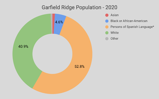
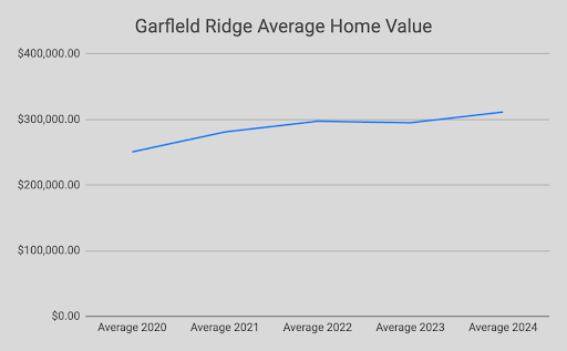
Garfield Ridge today is a neighborhood in demographic transition, though it moves at the measured pace of a community built on homeownership. Hispanics, predominantly Mexican-American families make up roughly half the population, with white residents comprising most of the remainder. The neighborhood's identity as a place for Chicago police officers, firefighters, and city workers has persisted across ethnic lines; it remains one of the more heavily first-responder populated neighborhoods in the city.
Archer Avenue is the commercial and cultural spine, lined with the kinds of local institutions that don't get written about much but hold a neighborhood together. Weber's Bakery, which has been on Archer since 1979 and in business since 1930, draws customers from across the Southwest Side for its chocolate cake donuts and Polish kolacky. The surrounding blocks mix Mexican taquerias, Polish delis, and the kind of old-school Chicago hot dog stands that seem immune to demographic change.
The CTA Orange Line connects residents to the Loop via the Midway station, and Interstate 55, the Stevenson Expressway runs along the northern edge, giving the neighborhood swift access to downtown and to the western suburbs. Wentworth Park, named for the old Long John himself, and LeClaire-Hearst Park provide green space and recreation across the community.
Garfield Ridge's history is longer and stranger than its bungalow blocks suggest. The same land where Jolliet and Marquette once carried their canoes across a swampy divide is now where families raise children within earshot of Midway's landing jets. What began as a portage became a prairie, then a farm, then a factory-worker suburb, then a site of public housing conflict, and now a majority-Latino middle-class neighborhood still finding its footing. The ridge itself hasn't moved. Everything around it has.
Trivia Answer
The body of water was called Mud Lake, a shallow, seasonally flooded wetland that sat in what is now Garfield Ridge. It served as the western half of the Chicago Portage, a critical link between the Chicago River and the Des Plaines River that allowed canoe travel between the Great Lakes and the Mississippi River. In 1673, French explorers Louis Jolliet and Father Jacques Marquette crossed this portage guided by the Kaskaskia tribe. Jolliet's vision of cutting a canal through the divide eventually led to the Illinois and Michigan Canal (opened 1848), which transformed Chicago into the transportation hub of the American Midwest. The name Garfield Ridge itself reflects this geography. The glacial ridge running through the neighborhood marks the ancient divide between Mud Lake's wetlands and the drier land to the south.
Stay connected with news and updates!
Join our mailing list to receive the latest news and updates from our team.
Don't worry, your information will not be shared.
We hate SPAM. We will never sell your information, for any reason.
